
A photo journal of Aurora from Raye to Comstock
By Doug MacDonald
This is a traverse of an SDOT “sidewalk” (which in many locations is an insult to the term “sidewalk”) on a major arterial served by two Metro routes critical to the Aurora corridor, the E Line Rapid Ride and the #5 - Greenwood-Phinney’s own bus.
“Bad" does not describe the conditions on this pedestrian corridor. Terrible would be kind. And this is actually a sidewalk people use, although it is understandable you might not notice if your only experience of it was zipping past in a car or on the bus. How can SDOT boast about being a walkable city or caring about pedestrian infrastructure in the face of this embarrassment.
There is an important fully visible attribute of this walk that these pictures don’t fully capture; out of the photographer’s discretion (no point particularly in capturing the guy zipping up his fly after aiming into the bushes over the guardrail) and occasionally the sense that “people photography," for example the males gathering for the card game in progress in the parking lot at the Hillside Inn, might even be dangerously unwelcome. If Seattle transportation policy has anything to do with equity in the face of disparate infrastructure conditions sustained by people whom we can wrap into a convenient euphemistic characterization as “marginalized” — that’s a significant component (but not all) of the demographic of quite a few people one encounters making the best use they can of this infrastructure.
Plenty of money has been spent to accommodate the people “passing through” in their vehicles. Next to nothing to the benefit of conditions for the people in this area personally affected by the terrible infrastructure left at roadside for them. These days this environmental justice problem in transportation is widely and generally acknowledged. I found it distressing to ground-truth the problem on a roadway I use all the time to get from one comfortable place to anther in the Seattle human-scape. On this stretch of sidewalk along Aurora, this human-dimension equity issue should get more more visibility than it has received in this photo journal.
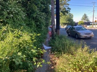
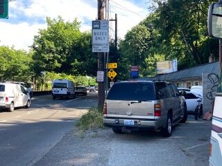
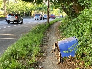
Anyway, let’s start at the dangerous intersection where Raye Street joins southbound Aurora at the south end of the bridge. There is a crosswalk and a curb ramp, so pedestrians even with mobility devices would seem to be invited on the walk I am about to take. Although it would be an act of derring-do just to try to cross on foot the constant stream of traffic exiting from off the bridge, just while another stream is accelerating in the opposite direction from Raye seeking to flow on to Aurora.

Looking north at the Raye Street on/off ramp
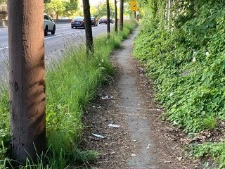
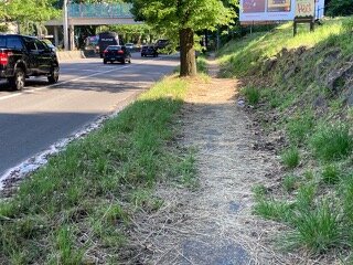
But oh, dear, let’s turn around from this intersection and look at what comes next on this walking journey. Looking south (photo below) or over your shoulder back north (the next photo), it is a threatened sensation to tip-toe past the foliage and squeeze around the telephone pole with the traffic moving 40 mph just inches to your left. And the squeeze continues for an uncomfortable distance.

Looking south

Looking north (back over your shoulder)
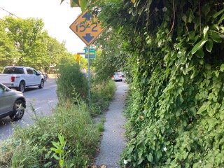
And it doesn’t get better, even as you are reminded of how fast (or faster) the cars, trucks and buses are moving.

The speed limit on this stretch of Aurora is 40 miles per hour.
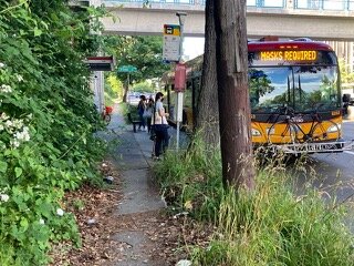
Pretty soon comes the bus stop for the #5.

Yes, this is how the bus stop looks.
Walk on, turn around, and check out the approach to the bus stop viewed from the south.
The #5 bus stop viewed from the south.
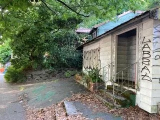
It gets worse. You're coming to the Hillside Inn. The Hillside Inn suffers from a sketchy reputation. Maybe the problem, if there is a problem, stems in part from how abysmally SDOT maintains the neighborhood infrastructure. And even fails to enforce parking regulations, so pedestrian passersby are all but literally forced into the roadway.
SDOT certainly can’t be blamed for paying too much attention to keeping this commercial arterial sidewalk in apple pie order.

Tree roots often cause uplift of arterial sidewalks.
Moving on, we are grateful to learn that we are in a Traffic Safety Project area (really?), because we are about to reach the pedestrian nightmare off-lane to Dexter.
The best of this is on video (not here), with the autos blasting off Aurora. Crossing speeding traffic is “take your life in your hands” scary. Who wants to see the video? The pedestrian I filmed basically attempted a highway “wildlife crossing” (on the video) opting to take his chances. I decided to cross at right angles a little further down the ramp. No ped sign. No marked crosswalk. Ridiculous.
Not sure what traffic safety project this is referring to…

Looking south at the offramp for Dexter Ave
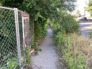
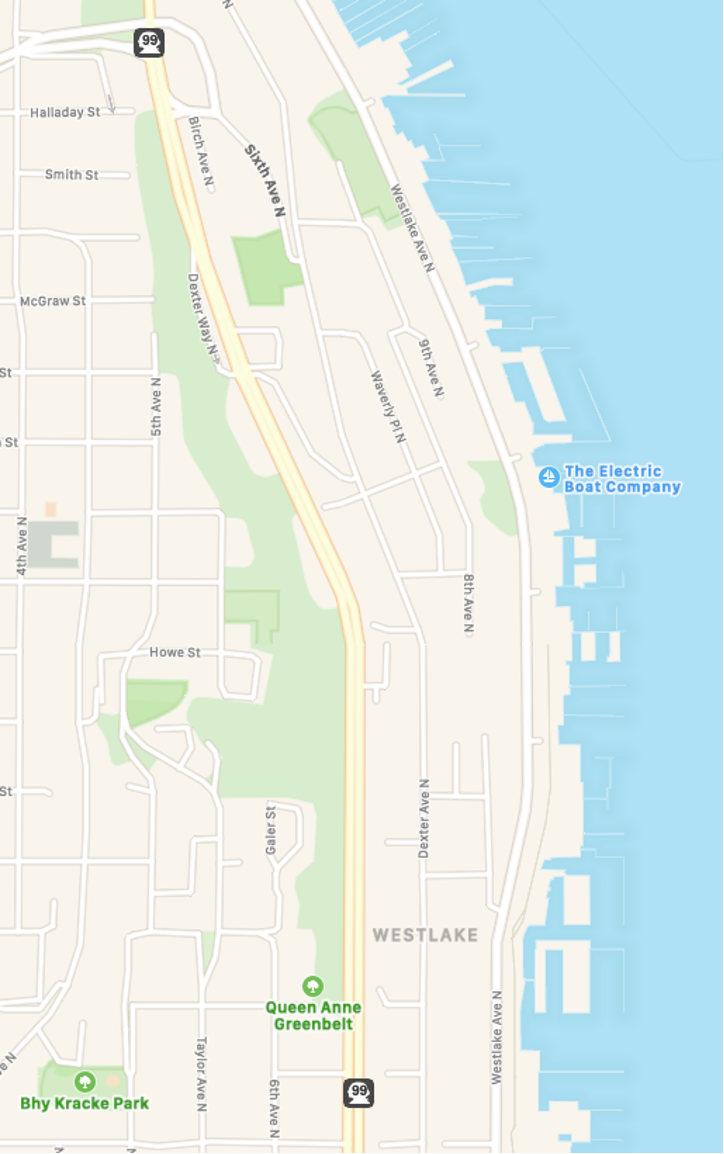
After safely dashing for dear life across the Dexter off-lane, next there is a short stretch of ordinary Seattle sidewalk. Noting special. Just uplifts and buckling.

A typical uplifted sidewalk along Aurora.
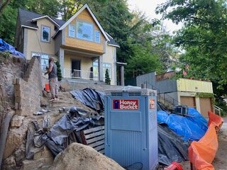
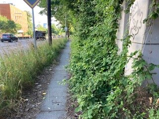
Soon we come to the Lynn Street E Line bus shelter which has needed a duff sweep for a couple of years. Then the car repair shop and a curious derelict property cheek-by-jowl with a remodeling of an old residence perched above the roadway and sidewalk - a century old, I learned from the contractor.
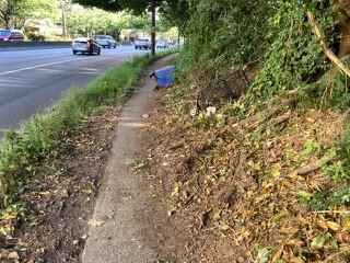
Then more “ordinary" SDOT sidewalk, just like any of our innumerable crumbling ordinary sidewalks, ordinary all over the city — in the course of breaking up before our eyes.

Did I mention that broken sidewalks are common?
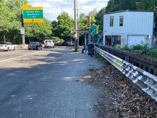
This brings us to the Aloha Inn (resident-managed transitional housing) where, mirabile dictu somebody actually is taking care of the sidewalk and there is a perfectly acceptable bus shelter for the #5.

The Aloha Inn
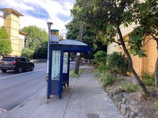
A much more accessible bus stop for the #5
Has a realm of First World Sidewalks finally been reached as downtown comes closer? Not a chance. The landscape reverts to jungle. What changed? There turns out to be an answer to that question, Soon to be revealed.
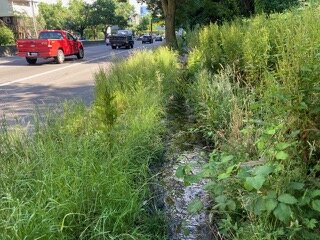
I was in for a surprise. Very soon the sidewalk literally disappears altogether. Under water. We have reached what I call The Swamp. This space actually demands very attentive threading through water and slick mud.

Welcome to The Swamp
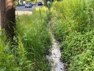
Video (available, but not here) reveals the stream over the sidewalk to be free flowing, even in late June.
An unusually dry Spring, yet the water still flows…
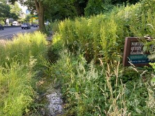
But revelation now comes! You are now advised by an overgrown sign that you are in a park! The Seattle Parks & Recreation Department North East Queen Anne Greenbelt. This is physical embodiment, sort of, of a long-ago inspiration for this location described on the website of Friends of Seattle’s Olmsted Parks:
“In their 1903 report, the Olmsted Brothers recommended a park in this vicinity: “Between the [QA] parkway and Lake Union, at or near Howe Street, there should be a local park extending down to the lake.” They note that it would “pay the city in the long run to take considerable area on this steep slope, because it is subject to landslides, and its occupation by streets and houses would involve difficulties and expenses which might eventually cost the city far more than the present value of the land.” Today the greenbelt offers a reprieve into nature with trails and benches within the wooded slope. Views from the site open up across Lake Union to the Cascade Mountains to the east.”
Here is what Seattle Parks & Recreation Department says about this greenbelt today:
“NE Queen Anne Greenbelt offers trail access and features benches, a great view to the East, the Cascades and Lake Union, and offers the perfect spot to watch the seaplanes arrive and depart.”
Really? Who knew? The map below shows the considerable extent of this park. It also suggests, speaking of transportation and environmental justice, that another walk might examine how the western fringe of this greenspace is maintained by SPR up on the top of the slope where quite a different demographic probably enjoys the park's amenities — like those great views of the seaplanes, the lake, and the mountains.
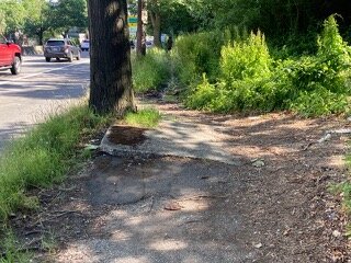
At the end of the streambed/“sidewalk” is an ineffectual drain (here seen looking north). More on that below.

Where The Swamp drains (?)
Then “ordinary” sidewalk resumes - totally impassable so a path has been beaten by users to its side.

Looking north
The jungle quickly closes back in on the sidewalk.

Without frequent attention, vegetation takes over.

A big blackberry cane looms out of the brush like a toll gate requiring tribute as it blocks the way to something appearing less forbidding.
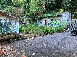
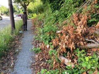
Approaching Galer, we discover that somebody has cleared the trees and underbrush. Although they’ve left the sidewalk a total mess.
A different type of neglect.
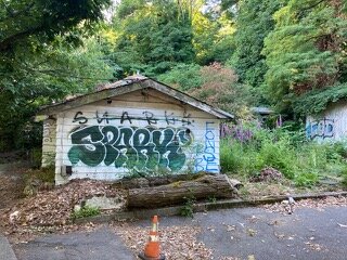
The clearing was probably to make sure drivers could see the billboards. Yet the sign says “Eden.” What a curious and delicious urban irony!

Welcome to The Eden

The vegetation is cut back when advertising revenue is on the line.
Or maybe “Eden” is to evoke those Lake Union views from the remodeled one and two bedroom apartments at The Eden - Queen Anne Hill, 602 Galer Street. Trust me on this: this neighborhood walk is not complete without checking The Eden website to see support for my hypothesis that the hill clearing was to enhance the great view for those lucky up-slope dwellers. That’s kind of an established Seattle paradigm.
“Tucked into the east Queen Anne slope, The Eden is your respite from whatever the world throws at you on the daily. [sic]. You’ll find yourself surrounded by green, high above the traffic bustle but still connected to wherever yours life is headed. The Eden is completely redesigned, stylish and modern apartments also come fully equipped to entertain your guests when you uncork your next bottle of Rosé while enjoying Queen Anne’s sweeping city views.”

Meanwhile, right under their wine glasses at (in?) Eden, the water off or out of the hillside runs in the street. In The Swamp section, it doesn’t smell so bad. But here it seems by odor that it may be a little less benign. Hello, Seattle Public Utilities?

Be glad this photo isn’t a scratch and sniff.
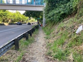
The Galer overpass and E Line Rapid Ride stop is soon reached where, with people waiting for the E Line or the #5, a red Jump bike blocks the sidewalk and another blocks the handrail of the stairway to the Galer Street overpass. I have frequently seen Jump bikes here from the bus, and never been able to figure out how they got here, or where they next are expecting to go. Sometimes there are three or four, and sometimes they seem to sit for days, usually partially blocking the stairway. They’re too heavy to carry up or down the stairs.
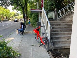
When this overpass was opened almost twenty years ago, each side of Aurora boasted a rail-mounted disability access stair lift required for ADA compliance. The lift has long since been abandoned and and its fittings and controls hardware removed. So this Metro stop has no functionality as a two way transit point to and from downtown (or north) for people with mobility disabilities living nearby on either side of Aurora. Hello, WSDOT? Meanwhile, the water ponding at the bottom of the stairway (“Potentially Slippery Surface”) is endemic. More four-season drainage out of the hillside (ice on a cold winter day) that was not cut off, as it should have been, in original design and construction or the stairway.
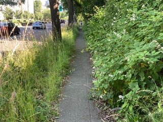
Walking on, the access to the Rapid Ride stop resumes the jungle paradigm.
Looking north (over the shoulder)
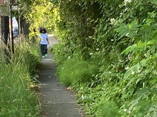
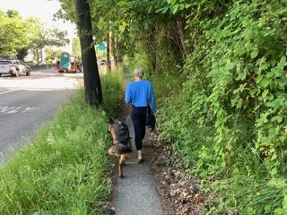
But people actually do walk here! despite the hostile overgrowth.
Finally, you reach Crosspointe Vista Apartments (or at least its backside) where there is actual evidence of someone’s sidewalk maintenance program including grinding of the uplifts. Was this part of an SDOT grinding initiative? Why here? Anywhere else on the Aurora corridor? What an unexpected indicia of sidewalk maintenance in this otherwise remarkable journey or horrendously neglected sidewalks. If a concrete grinder can be marshaled here, can't SDOT at least bring on an industrial weed whacker and a sidewalk sweeper, maybe, to unleash to the north?
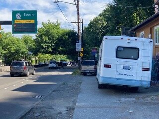
Anyway, from here on, noisy, cramped, but actual pretense of functioning sidewalks. At least for a bit of distance, Comstock to Roy still needs a scout by foot in its own right.

It feels good to be back in civilization.
Addendum
In case anyone thinks otherwise, let’s be clear that there are rules, and here is what the rules are, according to the Seattle Department of Construction and Inspection:
